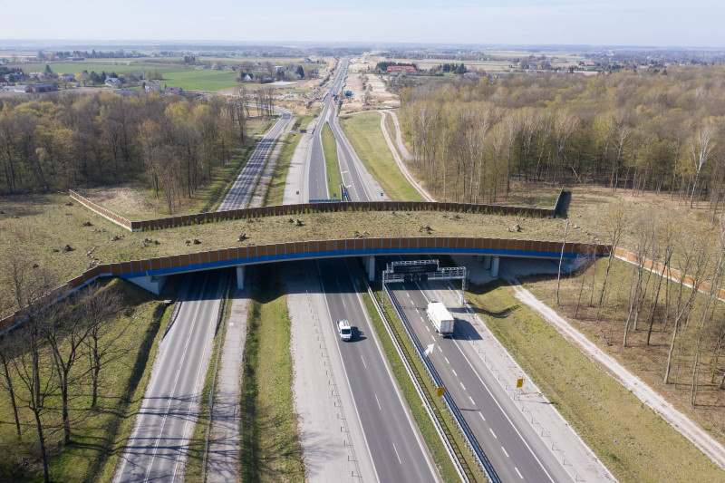
The Via Carpatia is a road crossing seven countries of Central and Eastern Europe. It runs from the Baltic port of Klaipeda in Lithuania to Thessaloniki, in Greece. Running along the border of NATO and of the European Union, the road promotes land connections with Russia, Belarus and Ukraine. But it also participates in uniting the countries of the zone into a geostrategic bloc. If the seven states in this project agree to build a road, they do not have the same vision of its objectives.
A road with strong economic opportunities
At first glance, the trans-European road project is justified from an economic point of view. For the countries concerned, the first goal is to improve road connectivity; in particular, for some of them, in relatively disadvantaged regions.
Boosting the Eastern part of the European Union
The Via Carpatia project was born in October 2006, during the International Conference in Łańcut. Lithuania, Slovakia and Hungary are represented alongside Poland. On October 22, 2010, a second conference was organized, again in Łańcut. The first four countries are then joined by Romania, Bulgaria and Greece.
The name “Via Carpatia”, in imitation of the Roman roads, refers to the Carpathian Moutains, a natural obstacle structuring the region, from south-eastern Poland to Romania. The route of the road partially overlaps existing roads. But the project aims to extend and connect them, giving them common characteristics, allowing vehicles to cross thousands of kilometers without changing the route.
The project participates in a logic of integration of the countries concerned into the European Union, of which they are all members. In fact, these states have been asking for several years for the Via Carpatia route to be included in the Trans-European TEN-T Network.
For these countries, the Via Carpatia is seen as an opportunity to develop the economy of relatively disadvantaged regions. This is the case in Poland and Slovakia. However, this does not apply to all countries: in Lithuania, Romania and Bulgaria, the regions crossed are not the least developed.
The Via Carpatia is officially due to be completed in 2025, although delays are already being considered. A study published in 2019 by four researchers from the Institute of Geography of the Polish Academy of Sciences evaluated the positive impact of the road on road accessibility in Europe. The authors consider that the project can fill a “gap” in the TEN-T network in Eastern Europe.
The study led by Piotr Rosik bases its conclusions on an equation, used to measure the road accessibility of a region, taking into account the travel time between two regions of the same importance, inside the region, towards the stranger, etc.
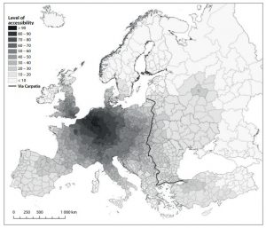
Map of road accessibility in european regions, PIOTR Rosik (dir.), 2019
The first map above, taken from the study led by Piotr Rosik, shows the level of accessibility of the different regions – at NUTS 3 statistical level – of the European Union and neighboring countries. We see, unsurprisingly, that connectivity is greatest around the economic and political heart of Europe: Western Germany – the Ruhr Valley – and Eastern Benelux. The network takes on a concentric shape, the accessibility being more and more reduced as we move away from the center.
The map highlights the Via Carpatia road, extended by the road between Thessaloniki and Istanbul. The regions crossed are relatively poorly connected compared to the heart of Western Europe.
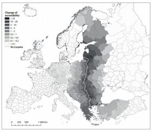
Map of the improvement in road accessibility due to the Via Carpatia road, PIOTR Rosik (dir.), 2019
The second map above shows the evolution of accessibility due to the Via Carpatia. Of course, this evolution is almost non-existent in Western Europe or in Russia. On the other hand, the direct effects of the road are very extensive around it, as far as central Turkey and northern Finland.
The Via Carpatia is therefore a major road infrastructure system for Central and Eastern Europe. Its expected impact on road connectivity is major, and concerns many countries.
From the Carpathians to the New Silk Roads
The Via Carpatia road should promote fast and fluid traffic from one end of Central Europe to the other. But beyond, via Istanbul and Turkey, the road connects the Baltic Sea to the countries of Central and South Asia. Several of these states are members of the TRAECA program, which associates them with the European Union in its transport policy: this is the case of Turkey, Iran, Kazakhstan – but also Ukraine.
If land trade flows pass through the Via Carpatia, this puts Central Europe in an intermediate position between Asian and Western European markets. Beyond that, the Via Carpatia integrates the road transport networks of Central Europe with transcontinental-scale corridors between China and Europe.
Central Europe is directly in contact with one of the land corridors of the New Silk Roads.
Vous devez souscrire à un abonnement EurasiaPeace pour avoir accès au contenu - Prendre votre abonnement